

Mapping India’s Infrastructure Future with Geospatial Intelligence
Setting the Context
Today, India stands at the brink of an infrastructure revolution. Over the last decade, the nation has made significant strides towards the future with notable advancements in smart cities and expressways, agricultural technology, as well as new-age energy grids...
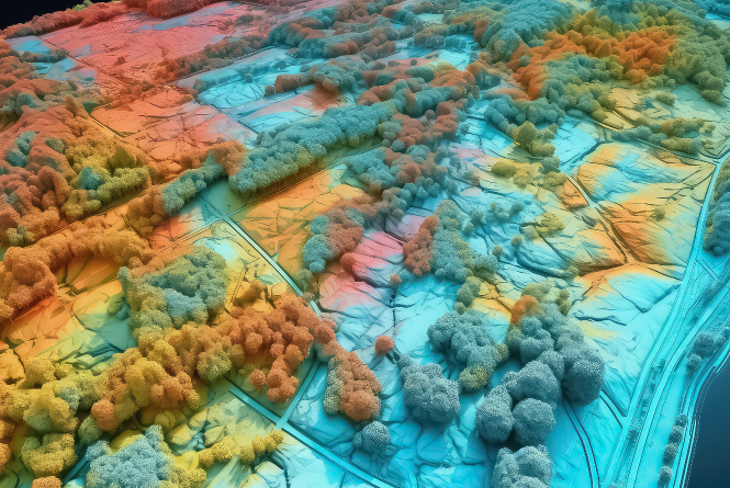
Geospatial Intelligence, or GIS-based Spatial Analytics, goes beyond developing just maps. Instead, this technology focuses on capturing, processing, and analysing spatial data that encourages smarter decisions...
In this article, we take a microscoping view of GIS and its importance in shaping India’s future, and how Mapex is leveraging AI and other new-age technologies for both private and public players to achieve these goals.
Simplifying Geospatial Intelligence
Before we go forward, let us quickly go through some of the frequently occurring terms that you will encounter throughout this article.
Geospatial intelligence refers to the use of location-based data...
- Mapping (GIS): Understanding “where” something is
- Remote Sensing: Using satellite/drones to observe land or infrastructure
- Data Engineering: Cleaning and organising data for use
- Analytics: Extracting patterns, forecasting, and optimising based on data
- BIM: To leverage new-age CAD and Infrastructure Modelling for efficiency
Together, these technologies convert raw data into meaningful insights that will drive decision-making.
A Closer Look at India’s Infrastructure Landscape
Some noteworthy objectives include:
- 150+ New Airports...
- 100+ Smart Cities...
- 80,000+ km of National Highways...
- Urban Mobility Reforms...
- Digital Infrastructure: BharatNet and 5G...
- Water, Sanitation, and Waste Management...
With such lofty goals... it is crucial for India to adopt location intelligence...
Geospatial Intelligence And Smarter Infrastructure
Geospatial intelligence supports every stage of infrastructure development:
1. Pre-Planning & Feasibility
- Land surveys, elevation models...
- Population and mobility heat maps...
- Risk analysis: flood zones, seismic risks...
2. Design & Engineering
- CAD and GIS integration...
- Precise boundary and layout planning
- Material and manpower estimations...
3. Execution & Monitoring
- Drone-based construction monitoring
- Real-time field data reporting
- Tracking timelines, compliance...
4. Post-Completion Maintenance
- Digital twins of infrastructure assets
- Predictive maintenance alerts
- Utility line mapping...
How Mapex Enables India’s GIS-Driven Future
- AI & ML tools for large-scale spatial analysis
- BIM expertise for efficiency
- Survey & drone teams for accurate data
- Custom application development
- Expertise in municipal, road, and utility projects
The Mapex Difference
- Municipal Projects: Accurate maps for governance
- Road & Highway Planning: Optimise route alignment
- Smart City Solutions: 3D models for zoning and planning
The Global Perspective
The global geospatial analytics market is projected to grow to $157 billion by 2030...
Conclusion: Mapping Tomorrow with Confidence
India is building faster than ever before... In such a scenario, geospatial intelligence, when integrated early, gives planners and policymakers the power to see problems before they occur...
We, at Mapex, are not just making this transformation possible but making it efficient as well...

Share this Article :
Published at: 21-05-2025