


India’s urbanisation journey is evolving at a rapid pace and stands at an important point. As the nation gears to house over 600 million people in urban areas in the next 10 years, it is crucial for authorities to plan cities that can not only withstand such a populace, but also help them access the quality of life required to achieve the status of a developed nation. The immediate challenges for government bodies include rapid urbanisation, sustainability, infrastructure development, and socio-economic disparities. In such a scenario, urban planners need the right set of tools to overcome these challenges and help citizens have a pleasant living experience.
One such solution that can help is a Geographic Information System. For the uninitiated, Geographic Information Systems (GIS) are digital platforms that capture, store, analyse, and visualise spatial data. The data generated by such a system helps planners to make better, evidence-based decisions grounded in geography.
At Mapex, we specialise in deploying customised GIS solutions that help our clients achieve an
array of objectives. Having worked closely with public agencies and private institutions, we have
a proven track record of excellence when it comes to delivering context-aware GIS solutions
tailored for the Indian urban landscape. With this blog, we talk about the most common
challenges urban planners face and how Mapex advanced GIS platforms can help overcome
them.
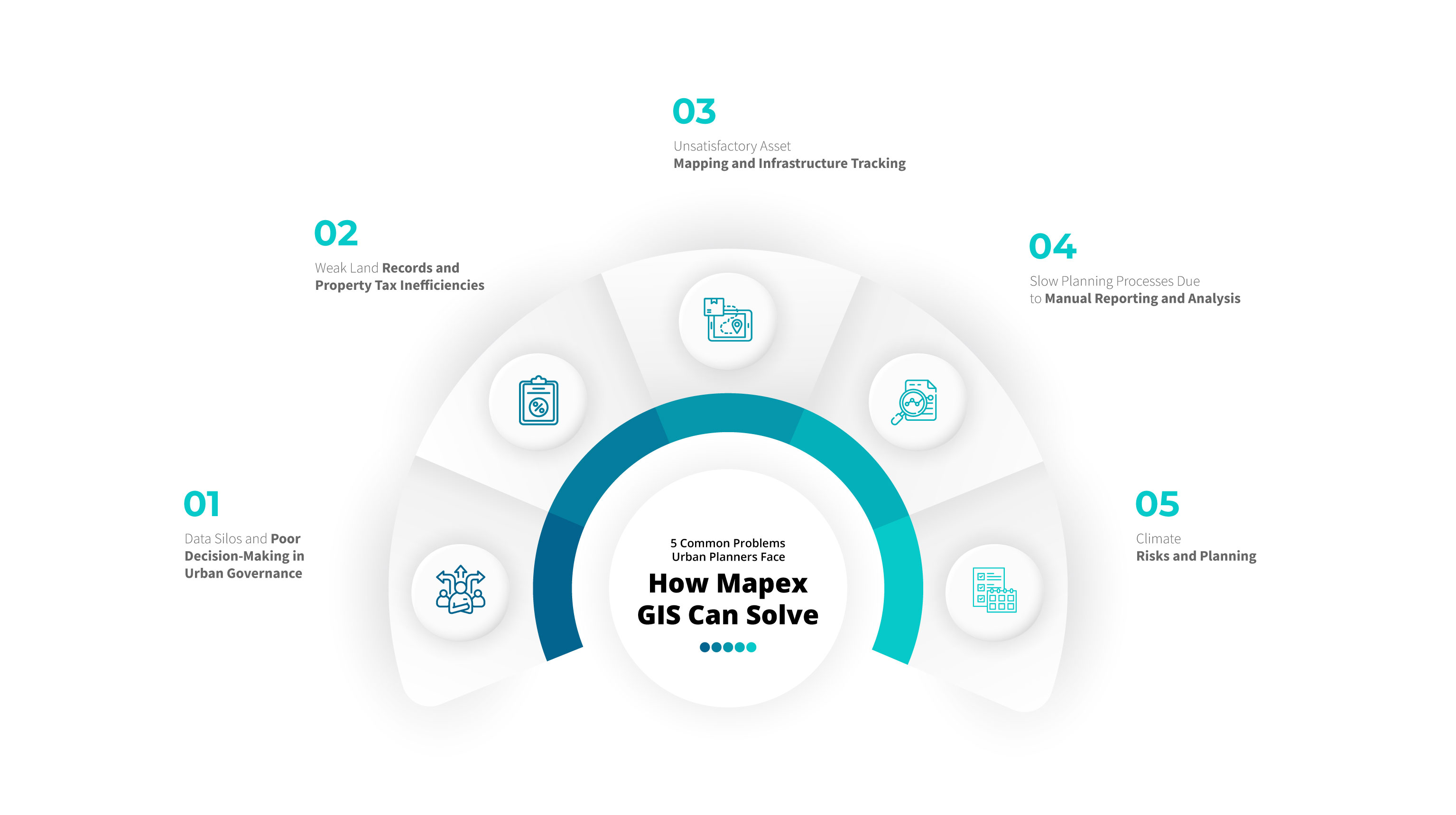
1. Data Silos and Poor Decision-Making in Urban Governance
When it comes to managing spatial data, urban bodies in India operate across multiple administrative layers. Whether it is development authorities, municipal bodies, utility companies, or transport bodies, every unit has its maps, reports, and information structure. However, the problem is that these datasets are often misaligned, incomplete, and outdated. Such an incompatible system can lead to inefficient spending of money, project delays, and miscommunication among departments.
This effect is felt more particularly when we are dealing with bigger cities, as the number of governing bodies increases. For instance, in fast-growing cities like Indore, Surat, or Lucknow, there is often a lack of unified spatial infrastructure, which can lead to the slowing down of infrastructure projects and, subsequently, costly delays.
At Mapex, we take the right set of measures to ensure that our growth is unparalleled and that our spatial infrastructure doesn’t hinder it. We specialise in creating integrated, digital GIS environments where multi-source spatial data from land records to utility networks is standardised, centralised, and ready for collaborative use, helping administrators better govern these cities.
2. Weak Land Records and Property Tax Inefficiencies
One of India’s most significant bottlenecks to development is its outdated urban land records. The data is often inconsistent, manually recorded, or mapped with poor resolution. Such records lead to overlapping boundaries, disputed ownership, and invalid data. This presents a difficulty for governments in enforcing zoning rules, acquiring land for public projects, or identifying tax liabilities. The unavailability of transparent records mean that property tax collections across the country remain far below potential, which results in revenue losses that consequently limit infrastructure upgrades.
Besides missing out on development, there are other problems that citizens face as well. These include unfair eviction notices, lengthy legal battles, and reduced quality of life.
Recognising these problems, we, at Mapex, leverage tools like PGLAB that digitise, validate, and geo-enable land records. Further, we also support automated tax billing and survey workflows. This technology-driven solution, adapted at scale by government authorities nationwide, will be pivotal in creating transparency, fostering trust, and strengthening municipal finances.
3. Unsatisfactory Asset Mapping and Infrastructure Tracking
While assets like streetlights, signage, bus stops, and electric poles seem minor individually, they are assets in any city’s infrastructure. Currently, India’s urban local bodies do not possess a complete and validated list of such assets, which leads to reactive maintenance rather than proactive. When bodies want to expand urban areas and monitor these assets, it becomes inefficient.
Traditional asset mapping is done manually and often lacks accurate location data or photos for verification. This leads to growing gaps between what is on paper and what is actually on the ground, especially in fast-growing or informal areas.
Mapex Ai-powered POI Collection Platform makes this easier by using mobile and vehicle-mounted tools to quickly identify, classify, and map city assets, helping authorities manage infrastructure more effectively.
4. Slow Planning Processes Due to Manual Reporting and Analysis
For every project, the government conducts rigorous feasibility studies and has to submit compliance reports as well as monthly progress dashboards. During these processes, urban planners spend considerable time compiling and formatting information. As data comes from different sources as well as formats, cleaning, processing and analysing this data takes a lot of time. These tasks, while seemingly insignificant, end up taking a lot of time as they affect budget allocation, stakeholder communication, and timelines under central schemes like AMRUT or Smart Cities Mission.
The problem is not just the volume of data, but the lack of automation. Even after spending hours gathering information, many planning offices find it difficult to derive insights, or visualise trends.
To solve this problem, Mapex has developed Mapexport. It’s a tool that automates the reporting process and is capable of integrating diverse datasets, generating visuals and charts, and producing ready-to-use reports that save time and improve decision clarity.
5. Climate Risks and Planning
India consistently faces a wide range of disasters and climate-related problems. Whether it is flooding in Bengaluru, heatwaves in Delhi, or recurring landslides in the Northern parts of India. As such risks increase, data can be an important ally when it comes to city plans and using them during such disasters. In case of emergencies, having accessible data can mean precious time saved and potentially, lives saved.
Leveraging GIS systems as well as climate-sensitive town planning are no longer luxuries but necessities.
At Mapex, we recognise this necessity and as a result, equip planning authorities with terrain modelling, satellite analytics, and ecological overlays to support sustainable infrastructure growth.
Conclusion: Smarter Cities Start with Smarter Maps
Urban India is changing rapidly. Without modern spatial intelligence, it is difficult to realise ambitious development plans that India has, as it prepares to welcome the Amrit Kaal (Golden Period). Authorities across cities face real obstacles. These include broken data systems, outdated land records, slow infrastructure updates, and limited attention to climate risks. The challenges are complex, but they also open a clear path to improvement. Indian cities now have the opportunity to grow in a way that is efficient and future-ready.
Mapex is helping governments and large organisations take that step. We offer GIS solutions that are designed to solve problems for Indian cities. Our customised systems are scalable and tested across urban projects. They give planners, engineers, and officials the clarity they need to act quickly and confidently.
The future of India’s cities will depend on how they use technology today. For us to usher in the Amrit Kaal, we will have to invest in better maps, smarter planning, and data we can trust. Mapex is proud to be part of that transformation.

Share this Article :
Published at: 04-08-2025